Jubilee line
| Colour on map | Grey | ||||||||||||||||||||||||||||||||
| Year opened | 1979 | ||||||||||||||||||||||||||||||||
| Line type | Deep Level | ||||||||||||||||||||||||||||||||
| Rolling stock | 1996 Tube Stock 7 carriages per trainset |
||||||||||||||||||||||||||||||||
| Stations served | 27 | ||||||||||||||||||||||||||||||||
| Length | 36.2 km (22.5 mi) | ||||||||||||||||||||||||||||||||
| Depots | Neasden, Stratford Market[1] | ||||||||||||||||||||||||||||||||
| Journeys made | 127,584,000 (per annum) | ||||||||||||||||||||||||||||||||
|
Rail lines of Transport for London
|
|||||||||||||||||||||||||||||||||
The Jubilee line is a line on the London Underground ("the Tube"), in the United Kingdom. It was built in two major sections - initially to Charing Cross in Central London, and later extended in 1999 to Stratford in east London. The later stations are notable for their larger size and safety features (both being attempts to future proof the line). Out of 27 stations served, 13 are below ground.
The Jubilee line is coloured silver/grey on the Tube map.
Contents |
Up to 1939
In 1932, the Metropolitan Railway built a branch from its main line at Wembley Park to Stanmore. The line, as with many others in the north-west London area, was designed to absorb commuter traffic from the new and rapidly expanding suburbs. The line presented the Metropolitan with a problem — so successful was the suburban traffic that by the early 1930s, the lines into Baker Street were becoming overloaded, a problem which was exacerbated by the post-war flight from the City of London to the West End of London.
At first the Metropolitan had advocated a new underground line roughly following the line of the Edgware Road between the tube station and a point near Willesden Green. Indeed, construction advanced as far as the rebuilding of Edgware Road station to accommodate 4 platforms of 8 car length. Things changed though with the formation of the London Passenger Transport Board (LPTB) and the subsequent absorption of the Metropolitan. The solution was now an extension of the Bakerloo line from Baker Street to serve St John's Wood and Swiss Cottage, thereby rendering the existing stations of Lord's, Marlborough Road and Swiss Cottage on the parallel route redundant, and negating the need for the Met's extension from Edgware Road station (it should be noted, however, that Swiss Cottage Met was proposed to remain open during peak hours for interchange with the Bakerloo, and that Lord's station would further open for special cricketing events. In the event, both closed permanently as war time economies). The line would rise between the Metropolitan tracks at Finchley Road, providing cross-platform interchange with the Metropolitan line. Continuing north to Wembley Park, the Bakerloo was to provide intermediate service on the Metropolitan line, allowing Metropolitan line trains to run Wembley Park to Finchley Road non-stop, cutting seven minutes from journey times. At Wembley Park, the Bakerloo would run on to serve Kingsbury, Queensbury, Canons Park and Stanmore. The Bakerloo extension, built as above, opened in 1939.
1939 to 1979, the Fleet line
The immediately pre- and post-war planning for the Tube network considered a series of new routes. The main results of this study concerned two major routes: the south to north-east "line C" (later constructed as the Victoria line) and lines 3 and 4, new cross-town routes, linking the north-east suburbs to Fenchurch Street, Wapping and variously Lewisham and Hayes.
The Fleet line was mentioned in a 1965 Times article, discussing options after the Victoria line had been completed — suggesting that the Fleet line could take a Baker Street—Bond Street—Trafalgar Square—Strand—Fleet Street—Ludgate Circus—Cannon Street route, then proceeding into south-east London.[2]
Line C opened as the Victoria line, in stages, between 1968 and 1972. Work on the north-east - south-west route continued.
In 1971 construction began on the new 'Fleet line'. Economic pressures, and doubt over the final destination of the line, had led to a staged approach. Under the first stage, the Baker Street to Stanmore branch of the Bakerloo line was joined at Baker Street to a new 2.5-mile (4 km) segment into central London, with intermediate stops at Bond Street and Green Park and terminating at a new station at Charing Cross, thereby relieving pressure on the West End section of the Bakerloo line between Baker Street and Charing Cross and also allowing increased frequencies on the section north of Baker Street.
The new tube was to offer cross-platform interchange between the Bakerloo and Fleet at Baker Street, as pioneered on the Victoria line. The work was completed in 1979. As part of the works, Trafalgar Square (Bakerloo) and Strand (Northern) stations were combined into a single station complex, Charing Cross. The existing Charing Cross station on the sub-surface District and Circle lines was renamed Embankment.
The new line was to have been called the Fleet line[3] after the River Fleet (although it would have only crossed under the Fleet at Ludgate Circus; the Central London section mostly follows the Tyburn). In 1975 when plans were underway to introduce the London Transport Silver Jubilee Bus fleet, the then Sales Manager of London Transport Advertising proposed to the Chairman of LTE, Rt Hon Kenneth Robinson PC, that the Fleet line should be renamed the Jubilee line. However, this idea was rejected due to the additional costs involved. Nevertheless, the project was subsequently renamed the Jubilee line for Queen Elizabeth II's 1977 Silver Jubilee following a pledge made by the Conservatives in the Greater London Council election of 1977. The original choice of battleship grey for the line's colour was based on the naval meaning of the word fleet; this became a lighter grey, representing the silver colour of the Jubilee itself.
The line was officially opened by the Prince of Wales on 30 April 1979, with passenger services operating from 1 May 1979.[4][5]
1979 to 1999
The Jubilee line of 1979 was to be the first of four phases of the project, but lack of funds meant that no further progress was made until the late 1990s.
- Phase 2 would have extended the line along Fleet Street to stations at Aldwych, Ludgate Circus, Cannon Street and Fenchurch Street.
- Phase 3 would have seen the line continue under the river to Surrey Docks (now Surrey Quays on the East London Railway tube station with a branch to both Lewisham via New Cross, and to New Cross Gate Station.
- Phase 4 was the possible continuation of the Lewisham branch to take over suburban services on the Addiscombe and Hayes (Bromley) Branch.
An alternative plan was devised in the 1970s to extend the Jubilee line parallel to the River Thames: this would have taken the line from Fenchurch Street to Thamesmead via St Katharine Docks, Wapping, Surrey Docks North, Millwall (near to South Quay Docklands Light Railway station, North Greenwich, Custom House, Silvertown, Woolwich Arsenal, thence to Thamesmead. The depot would have been at Beckton, roughly on the site of the current Docklands Light Railway Depot. However the 'River line', as this extension was called, was deemed too expensive and construction of the extension never proceeded.
Changes in land use, particularly the urban renewal of the Docklands area, caused the project to extend the line beyond Charing Cross to change considerably in the 1970s, 1980s and 1990s. The Jubilee Line Extension, as the eventual project became known, opened in three stages in 1999. It split from the existing line at Green Park creating a one-station branch to Charing Cross, which is now closed (although it is still maintained for reversing trains at times of disruption, and for occasional use as a film set). The line extends as far as Stratford, with ten intermediate stations.
There have been other proposals to extend the line serving the docks.[6]
2005 upgrade
The Jubilee line closed for a scheduled five-day period starting on 26 December 2005 in order to add an extra car to each of the six-car trains.[7] The line had to be closed while this work was done as six and seven car trains could not run in service at the same time because the platform edge doors at Jubilee Line Extension stations could not cater for both train lengths simultaneously. Additionally, an extra four complete trains were added to the fleet, bringing the total to 63. The result is a 17% increase in capacity at peak times, allowing 6,000 more passengers per day to use Jubilee line services. The signalling system was also upgraded. Work was completed and the line reopened two days ahead of schedule, on 29 December 2005.
Current Jubilee line
The Jubilee line is the newest line of the London Underground network. The trains were upgraded in 1995 to the 1996 stock.
Station features
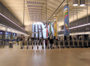
Stations on the Jubilee Line Extension feature:
- step free access to street level
- state-of-the-art architecture
- wheelchair access
- station protection doors
The station protection doors prevent people from falling on the track by automatically opening only when the train is exactly in line with them. A chime alerts the protection door sensor to shut just before the train doors. This prevents people jumping onto the track or train in the last minute. The open air stations begin at Stanmore and end at Finchley Road. On the other side of the line the open air stations start at Stratford and end at Canning Town.
Against these improved features, the Jubilee Line Extension stations have been heavily criticised for very longwinded and poorly planned (although expensive to build) connection facilities with other Underground lines, compared for example to the Victoria line, the previous cross-London line built.
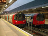
Rolling stock
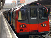
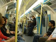
When the Jubilee line was opened, it was operated by 1972 stock. In 1984 this was partially replaced by the new 1983 stock, the displaced 1972 stock being transferred to the Bakerloo line. The 1983 stock proved to be unreliable and troublesome in service, with single-leaf doors making passenger loading and unloading a slower process than on other stock with wider door openings. With the construction of the Jubilee line Extension, the opportunity was taken to introduce new trains, and today the line is worked by 1996 stock, which has an exterior similar to the 1995 stock in use on the Northern line but (in spite of the confusing naming) is technically less advanced. The new rolling stock has internal displays and automated announcements to provide passengers with information on the train's route - at first they simply listed the destination of the train, and subsequently also listing the name of the next station and interchanges there. The 1996 stock uses a different motor to the 1995 stock and has a motor design similar to Class 465 Networker trains. Subsequent modifications also made the text scroll across the internal display instead of just appear in it.
Future
2009/2010 Upgrade
A project is currently under way to convert the Jubilee line to automatic train operation, using the SelTrac system in use on the Docklands Light Railway.[8] When complete, the new system will enable London Underground to run more trains, increase capacity by 33 per cent and to cut journey times by around 22 percent.[9] Equipment installation and testing for the new systems began in late 2006, and the line upgrade work has required the closure of sections of the Jubilee line on each weekend during 2009. Although the project was due for completion in March 2009, the Jubilee line closures are to continue into 2010[10]. A revised completion date of Easter 2010 has been missed, with closures continuing until October 2010 at the earliest, leaving the project at least 17 months behind schedule.[11]
The programme of closures has been criticised by local politicians[12], as well as by the management of venues such as Wembley Stadium and The O2 because visitors to major concerts and sporting events have had to travel by rail replacement bus.[10][13] The management of the project by Tube Lines has been criticised by London TravelWatch for its delayed delivery date,[14] and a report by the London Assembly referred to the weekly line closures as "chaotic".[15][16]
Thamesmead branch
When North Greenwich was opened, it was constructed to enable a branch extension to be built eastwards to Thamesmead. At present there are no plans to construct this branch route.
West Hampstead Interchange
Plans were put forward in 1974 and again in 2004 for a West Hampstead interchange, to connect the three West Hampstead stations in one complex, but plans were put on hold in 2007 due to uncertainty over the North London Line rail franchise.[17]
Map
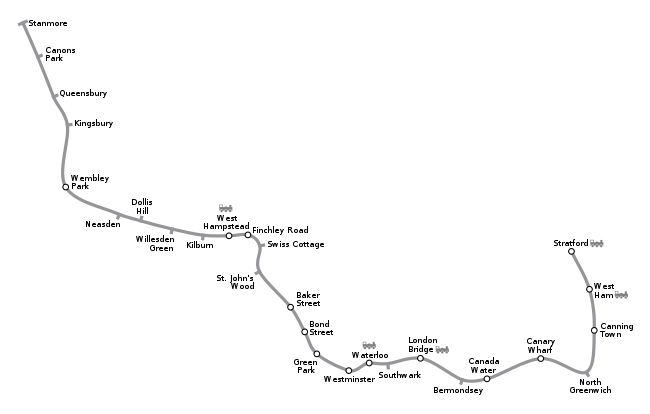
Stations
| Jubilee line | ||||||||||||||||||||||||||||||||||||||||||||||||||||||||||||||||||||||||||||||||||||||||||||||||||||||||||||||||||||||||||||||||||||||||||||||||||||||||||||||||||||||||||||||||||||||||||||||||||||||||||||||||
|---|---|---|---|---|---|---|---|---|---|---|---|---|---|---|---|---|---|---|---|---|---|---|---|---|---|---|---|---|---|---|---|---|---|---|---|---|---|---|---|---|---|---|---|---|---|---|---|---|---|---|---|---|---|---|---|---|---|---|---|---|---|---|---|---|---|---|---|---|---|---|---|---|---|---|---|---|---|---|---|---|---|---|---|---|---|---|---|---|---|---|---|---|---|---|---|---|---|---|---|---|---|---|---|---|---|---|---|---|---|---|---|---|---|---|---|---|---|---|---|---|---|---|---|---|---|---|---|---|---|---|---|---|---|---|---|---|---|---|---|---|---|---|---|---|---|---|---|---|---|---|---|---|---|---|---|---|---|---|---|---|---|---|---|---|---|---|---|---|---|---|---|---|---|---|---|---|---|---|---|---|---|---|---|---|---|---|---|---|---|---|---|---|---|---|---|---|---|---|---|---|---|---|---|---|---|---|---|---|
|
||||||||||||||||||||||||||||||||||||||||||||||||||||||||||||||||||||||||||||||||||||||||||||||||||||||||||||||||||||||||||||||||||||||||||||||||||||||||||||||||||||||||||||||||||||||||||||||||||||||||||||||||
| Station | Image | Opened | Additional information |
|---|---|---|---|
| Stanmore |
10 December 1932 | map 1 | |
| Canons Park | 10 December 1932 | Opened as Canons Park (Edgware); renamed 1933map 2 | |
| Queensbury | 16 December 1934 | map 3 | |
| Kingsbury |
10 December 1932 | map 4 | |
| Wembley Park |
14 October 1893 | Transfer to Metropolitan linemap 5 | |
| Neasden* | 2 August 1880 | map 6 | |
| Dollis Hill* | 1 October 1909 | map 7 | |
| Willesden Green* | 24 November 1879 | map 8 | |
| Kilburn* |
24 November 1879 | Opened as Kilburn & Brondesbury; renamed 25 September 1950map 9 | |
| West Hampstead* |
30 June 1879 | map 10 | |
| Finchley Road | 30 June 1879 | Transfer to Metropolitan linemap 11 | |
| Swiss Cottage | 20 November 1939 | map 12 | |
| St John's Wood | 20 November 1939 | map 13 | |
| Baker Street | 1 May 1979 | Change for Bakerloo, Circle, Hammersmith & City, and Metropolitan linesmap 14 | |
| Bond Street | 1 May 1979 | Change for Central linemap 15 | |
| Green Park | 1 May 1979 | Change for Piccadilly and Victoria linesmap 16 | |
| Westminster |
22 December 1999 | Change for Circle and District linesmap 17 | |
| Waterloo |
24 September 1999 | Change for Bakerloo, Northern and Waterloo & City linesmap 18 | |
| Southwark ( |
20 November 1999 | map 19 | |
| London Bridge |
7 October 1999 | Change for Northern linemap 20 | |
| Bermondsey |
17 September 1999 | map 21 | |
| Canada Water |
17 September 1999 | map 22 | |
| Canary Wharf |
17 September 1999 | Change for Docklands Light Railwaymap 23 | |
| North Greenwich |
14 May 1999 | map 24 | |
| Canning Town |
14 May 1999 | map 25 | |
| West Ham |
14 May 1999 | Change for District and Hammersmith & City linesmap 26 | |
| Stratford |
14 May 1999 | Change for Central line and Docklands Light Railwaymap 27 | |
| * - Between Finchley Road and Wembley Park, the Jubilee line right of way widens to four tracks. Jubilee line trains run on the two inner tracks. Flanking the Jubilee line are tracks used by the Metropolitan line. Metropolitan line trains run non-stop from Finchley Road to Wembley Park, skipping West Hampstead, Kilburn, Willesden Green, Dollis Hill, and Neasden stations. Willesden Green and Neasden stations have platforms on the Metropolitan line tracks, but Met trains only stop here during emergencies, or when there are major operating issues with either the Metropolitan and/or Jubilee lines. | |||
Former stations
| Station | Opened | Closed |
|---|---|---|
| Charing Cross | 1 May 1979 | 19 November 1999 |
The Jubilee line platforms at Charing Cross are still used but not for passengers - when the service is suspended between North Greenwich/Canary Wharf and Stratford, one in every three trains will terminate at Green Park, go to Charing Cross, reverse, and start a service from Green Park. The old Charing Cross station is a popular set for films.
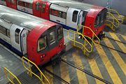
Depots
The Jubilee line is currently served by two depots, Neasden Depotmap 28 located between the Neasden and Wembley Park Stations and Stratford Market Depotmap 29 between the Straford and West Ham stations.[1]
Gallery
| Images | |||||||||
|
|||||||||

Additional images are available from the Commission for Architecture and the Built Environment (CABE) case studies for the stations at Canary Wharf,[18] North Greenwich,[19] Southwark,[20] and Stratford.[21]
Maps
|
|
References
- ↑ 1.0 1.1 "London Underground Key Facts". Transport for London. http://www.tfl.gov.uk/corporate/modesoftransport/londonunderground/1608.aspx. Retrieved 2008-05-21.
- ↑ "More Tube Lines Discussed". The Times. 27 April 1965.
- ↑ Willis, Jon (1994). Extending the Jubilee Line: The Planning Story. London Transport.
- ↑ "Jubilee Line, Dates". Clive's Underground Line Guides. http://www.davros.org/rail/culg/jubilee.html#dates. Retrieved 2008-02-12.
- ↑ Rose, Douglas (1999). The London Underground, A Diagrammatic History. Douglas Rose/Capital Transport. ISBN 1-85414-219-4.
- ↑ LDDC
- ↑ "Travel advice for the festive season". TFL. 19 December 2005. http://www.tfl.gov.uk/corporate/media/newscentre/archive/3816.aspx. Retrieved 9 March 2010.
- ↑ "Network tests for new signalling systems". Tube Lines. 2005-08-24. http://www.tubelines.com/news/releases/200602/20050824.aspx. Retrieved 2008-07-11.
- ↑ "Transforming the Jubilee line". TfL. 2009. http://www.tfl.gov.uk/corporate/projectsandschemes/10142.aspxhttp://www.tfl.gov.uk/corporate/projectsandschemes/10142.aspx. Retrieved 1 December 2009.
- ↑ 10.0 10.1 Murray, Dick (9 October 2009). "Jubilee line closures to go on next year". http://www.thisislondon.co.uk/standard/article-23754564-jubilee-line-closures-to-go-on-next-year.do. Retrieved 1 December 2009.
- ↑ "Line closures for March-August 2010" (pdf). TfL. 2010. http://www.tfl.gov.uk/assets/livetravelnews/realtime/tube/track-closures.pdf. Retrieved 10 March 2010.
- ↑ Forham, Ed (19 August 2009). "Don't close our community off at the weekends, please". http://474towin.blogspot.com/2009/08/dont-close-our-community-off-at.html. Retrieved 4 December 2009.
- ↑ Barney, Katharine; Singh, Amar (20 May 2009). "O2 not thrilled as Jubilee line shuts for Michael Jackson's big tour". http://www.thisislondon.co.uk/standard/article-23695351-o2-not-thrilled-as-jubilee-line-shuts-for-michael-jacksons-big-tour.do. Retrieved 1 December 2009.
- ↑ "Comment on Jubilee Line delays". London TravelWatch. http://www.londontravelwatch.org.uk/news.php?id=668. Retrieved 1 December 2009.
- ↑ "Tube crowds 'at shocking levels'". BBC News. 1 December 2009. http://news.bbc.co.uk/1/hi/england/london/8387560.stm. Retrieved 1 December 2009.
- ↑ "Too close for comfort: Passengers' experiences of the London Underground". London Assembly Transport Committee. December 2009. http://www.london.gov.uk/assembly/reports/transport/too-close-for-comfort.pdf. Retrieved 4 December 2009.
- ↑ "Station interchange plans put on hold". Camden New Journal. 2007-03-15. http://www.thecnj.co.uk/camden/031507/news031507_12.html. Retrieved 2008-07-29.
- ↑ "Canary Wharf Underground Station". Commission for Architecture and the Built Environment (CABE). http://www.cabe.org.uk/default.aspx?contentitemid=1096&field=btstr&term=Transport&type=1. Retrieved 2008-03-01.
- ↑ "North Greenwich Underground Station". Commission for Architecture and the Built Environment (CABE). http://www.cabe.org.uk/default.aspx?contentitemid=1094&field=btstr&term=Transport&type=1. Retrieved 2008-03-01.
- ↑ "Southwark Underground Station". Commission for Architecture and the Built Environment (CABE). http://www.cabe.org.uk/default.aspx?contentitemid=316&field=btstr&term=Transport&type=1. Retrieved 2008-03-01.
- ↑ "Stratford Station". Commission for Architecture and the Built Environment (CABE). http://www.cabe.org.uk/default.aspx?contentitemid=288&field=btstr&term=Transport&type=1. Retrieved 2008-03-01.
External links
- "Photographic Archive". London Transport Museum. http://photos.ltmcollection.org. Retrieved 2008-07-11.
- "Jubilee line facts". Transport for London. http://www.tfl.gov.uk/tfl/corporate/modesoftransport/tube/linefacts/?line=jubilee. Retrieved 2008-07-11.
- "Jubilee Line". Clive's Underground Line Guides. 2008-01-21. http://www.davros.org/rail/culg/jubilee.html. Retrieved 2008-07-11.
- Saint, Andrew (20 January 2000). "The Jubilee Line Extension". London Review of Books. http://www.lrb.co.uk/v22/n02/sain01_.html. Retrieved 2008-07-11.
- "Jubilee line extension". http://www.tubephotos.com/?goto=jubileelineextension&thumbs=ok. Retrieved 2008-07-11. (photo gallery)
| West: | Crossings of the River Thames | East: |
|---|---|---|
| Westminster Bridge | Between Westminster and Waterloo |
Bakerloo line between Embankment and Waterloo |
| Rotherhithe Tunnel | Between Canada Water and Canary Wharf |
Greenwich foot tunnel |
| Docklands Light Railway between Island Gardens and Cutty Sark |
Between Canary Wharf and North Greenwich |
Blackwall Tunnels |
| Blackwall Tunnels | Between North Greenwich and Canning Town |
Thames Barrier |
|
|||||||||||||||||||||||||